Lake Whatcom, the drinking water source for over 100,000 Whatcom County residents, faces an onslaught of threats — from logging and development, to pesticides and invasive mussels hitching rides on uninspected boats. Pollution of Lake Whatcom is on the rise, making drinking water treatment more costly, and the byproducts unhealthy for people to consume. Water treatment and lake restoration will only get more costly the longer we wait.
Lake Whatcom’s annual health check-up released by the WWU Institute for Watershed Studies indicates that phosphorus levels in the lake, as well as other indicators of water quality, are not improving. We need to pick up the pace and exceed our phosphorus reduction targets.
The best, most immediate way to protect this drinking water source is for Whatcom County to approve a fair, appropriate Lake Whatcom stormwater utility fee for the recently-formed Lake Whatcom Stormwater Utility area (or “stormwater district”), for unincorporated property owners within the watershed to help fund desperately needed services (City of Bellingham residents in the watershed already pay this). Without the help of residents around the lake pitching in, there is not enough funding to adequately service your drinking water. This way, everyone who boats, drives, landscapes, and lives in the watershed will be a part of keeping drinking water in Lake Whatcom safe.
What is a stormwater district?
A stormwater district is an area identified by watershed boundaries — an area where all rainfall eventually drains into a particular water body. This rain carries pollutants, especially phosphorus (see the last 2 questions on this page) from fertilizers, septic systems, land development, pet waste, and more. A stormwater district helps generate revenue from a fee — typically based on the amount of impervious surfaces (roofs, driveways) on someone’s property in the watershed — to pay for projects that will protect or improve water quality— because water that doesn’t get naturally filtered by pervious surfaces (soil, wooded areas, etc) carries more pollutants Stormwater districts are also known as Sub-zones of a Flood Control Zone District. In Whatcom County, there are currently four sub-zones with the intent of stormwater and/or flood protection: Birch Bay, Lynden/Everson, Acme/Van Zandt, and Everson/Nooksack/Sumas.
Why is this important for our drinking water?
Living, driving, and recreating near the lake can affect drinking water quality — even if you’re conscientious about not over-applying fertilizers, cleaning up after pets, and making sure your septic system is in good shape. A stormwater district will generate revenue based on the direct impact people have on water quality by living in the Lake Whatcom watershed. Currently, Whatcom County funds the Lake Whatcom Management Program from a variety of sources including the County-wide Flood Fund, which is close to running out of reserves in case of a major flood.
A stormwater district will provide an appropriate and equitable source of funding for protecting our drinking water. People whose property is nowhere near Lake Whatcom, like Lynden residents, end up paying into improving drinking water they don’t even use, while Lake Whatcom residents outside Bellingham’s limits aren’t currently required to help fund protecting their own drinking water.
When are fees assessed?
If the stormwater fee is approved before the end of June 2019, then fees will be assessed and included in your 2020 tax statement.
Who is in the stormwater district?
Everyone in the County portion of the Lake Whatcom watershed is in the district. The City of Bellingham has their own stormwater district, so residents in city limits are excluded.
I live in the City portion of the Lake Whatcom watershed. Will this affect me?
It will not! City of Bellingham residents already pay a stormwater fee on their annual tax bill and pay a watershed fee on their water bill.
I live in the County portion of the Lake Whatcom watershed. How much will this cost me?
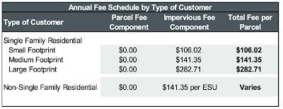
First, it depends on what the Whatcom County Council decides. The citizen Lake Whatcom Stormwater Utility Committee recommended a rate structure based on the impervious surface footprint of your property. A small footprint is less than 2,500 square feet. A medium footprint is 2,501 to 8,400 square feet — which costs less than $12 per month to protect and restore 100,000 peoples’ drinking water. A large footprint is over 8,400 square feet. See table below.
What if I already made improvements to my property with the Homeowner Incentive Program? Do I get a discount?
It depends on what the Whatcom County Council decides upon for credits or price fee reductions. The Committee did not make a decision on this subject; however, members of the committee were inclined to support a property owner moving down to the small footprint charge if they participated in HIP (see table above).
What will the funding be used for?
Funding will initially be used for the County’s contribution to the Homeowner Incentive Program (HIP) and for projects along roadways and ditches to collect stormwater before it hits the lake (“stormwater capital projects”). HIP provides technical and financial assistance to Lake Whatcom Watershed residents to complete water quality landscape improvements on their property that reduce runoff and pollution entering the lake.
The County currently funds HIP and stormwater capital projects through the County-wide Flood Fund, which means someone living in Blaine contributes to water quality benefits they will not be able to realize.
How did the County pay for programs in the Lake Whatcom watershed before the stormwater district?
The County funds the Lake Whatcom Management program from the Real Estate Excise Tax (REET), the Road Fund, and the Flood Fund. REET and the Road Fund are restricted to capital projects, while the Flood Fund is unrestricted so it funds the Homeowner Incentive Program.
Where does phosphorus come from?
Phosphorus comes from leaky septic systems, yard waste like grass clippings and leaf litter, fertilizers, land clearing and disturbance, some soaps and detergents, and animal and pet waste. When it rains, these sources make their way into water bodies like Lake Whatcom. Stormwater runoff is especially exacerbated when there are significant amounts of impervious surfaces in the watershed like roads, rooftops, and sidewalks allowing the water to rush into the lake without any natural filtration.
Why do we want to reduce phosphorus entering Lake Whatcom?
Excess phosphorus causes algae to grow on the surface of water. There are health impacts and huge costs to people associated with drinking heavily-treated water from a source that has significant algae growth. The treatment process requires a lot of chlorine gas to remove the algae and disinfect the water before it reaches the tap. When chlorine reacts with algae, disinfection byproducts such as chloroform – a known carcinogen – remain in our tap water., Thankfully, the City of Bellingham has a pretreatment facility coming online in 2019 that will reduce the need to use lots of chlorine to treat the water, but this is coming with a $14 million price tag. Another stage of treatment, if pollution continues, would likely cost taxpayers even more.
Too much algae can also create dead zones, where there’s not enough oxygen in the water, which aquatic life relies on to breathe — just like we do! Dead zones are created when a large algae bloom dies and the oxygen is consumed by the decaying matter. This is one of the main reasons Lake Whatcom is on a 50-year plan to reduce the amount of phosphorous entering the lake.
Questions? Contact Karlee Deatherage at karleed@re-sources.org